
Compare Vismo with...
Use Vismo and save: £1,717.20
and 50 working days.
Methodology → Cost calculated based on the average hourly rate of £33, Working days calculated from over 1000 analysed rail monitoring jobs in the UK.
Real-World Rail Visualisation
See your track and its structural condition overlaid on high-resolution maps or 3D models. By visualising deformations, wear and track geometry in their actual location, you gain immediate spatial context - helping teams pinpoint issues faster, plan targeted maintenance and communicate findings clearly to stakeholders.
Instant Threshold Alerts
Configure custom safety and performance limits in seconds. Whenever a reading breaches a critical threshold, stakeholders receive immediate notifications via email or in-app, so you can act before minor issues become major delays.
Centralised Data Capture
Upload measurements straight from the field or office into one secure platform. No more error-prone spreadsheets or lost email attachments - just accurate data on demand.
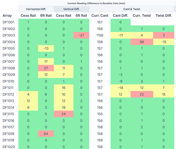
Vertical, horizontal, CANT and twist differences? No more spreadsheet formulas - it's all calculated for you!
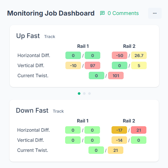
Interactive Dashboards & Analytics
Visualise every project's health in real time. Our intuitive dashboards highlight trends, anomalies and hot-spots across your monitored rail network, empowering engineers and project managers to make data-driven decisions with confidence.

Collaborative & Scalable Platform
Grant role-based access to surveyors, civil engineers, asset owners and your subcontractors. Whether it's a week-long site check or a 12-month monitoring programme, Vismo scales with your needs - enabling seamless teamwork and reducing project risk.
Monitor Rail with Confidence
From track geometry to structural integrity - get real-time insights that keep your network safe and on schedule.
Smart Alerts
Be notified when thresholds are hit.
Tool-Agnostic
Works with the hardware you already use – Trimble, Leica.
Visual + Contextual
Overlay data on plans, drawings or models.
Cloud-Based Confidence
Always available, always accurate.
Monitor Projects Without Losing Sleep
Surveyors, contractors, and engineers use Vismo to track critical data and stay in control.